
Wednesday, February 26, 2014
1964 Alaska Earthquake Lecture (webcast)
This March 27th marks the 50th anniversary of the 1964 Alaska Earthquake. To listen to a lecture about the 1964 quake and or other geology-related lectures (Yellowstone volcano, etc.), CLICK HERE. NOTE: The Earthquake lecture was webcast live on February 26 - If the lecture is not on the website yet, it should be posted soon (check back later). 
Tuesday, February 18, 2014
Density Lab: Gabbro, Basalt, Granite

Students results will vary because they are kids! - AND not all granites, basalts, and gabbros contain exactly the same minerals. According to About.com the density of granite ranges from 2.6-2.7 g/cm3 and basalt is 2.8-3.0 g/cm3. Since gabbro and basalt are made of the same minerals, their densities are similar. Gabbro's density ranges from 2.7-3.3 g/cm3.
The day after the lab is a good time to question the students about the significance of rock densities. Here are some questions for discussion:
1. What do you think causes some rock types to have higher densities than others? (Assuming there are no air pockets in the rock, the types of minerals will determine the density. Granite contains lots of quartz and feldspar - both fairly light minerals, whereas basalt and gabbro are made of heavier minerals.)
2. Consider a zone of subduction. Why is it that when ocean crust and continental crust collide, the ocean crust always goes under the continental crust, and not vice versa? (Ocean crust is made of basalt and continental crust is mostly granite.)
3. Which would be less dense - granite, or magma that contains the same minerals as granite? (The molten minerals would less dense for the same reason hot water is less dense than cold water, and hot air is less dense than cold air. Molecules that are moving faster tend to be farther apart. This is why molten material tends to melt its way to the surface. It's a density thing!)
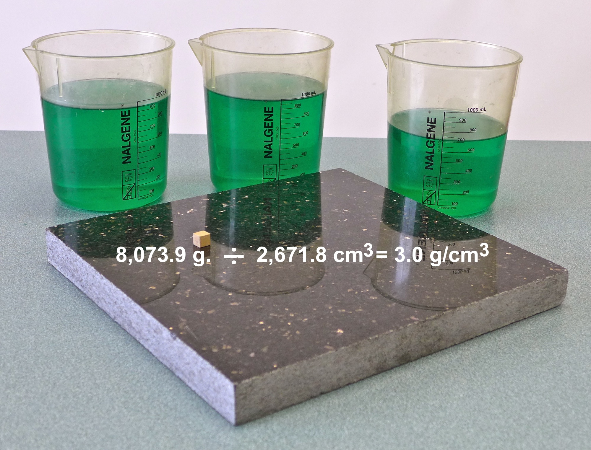
4. I have a large scrap of gabbro counter-top, and I ask students, "How would you determine the density of this piece of gabbro ?" (They would need to find the mass, and then measure the length, width, and height to determine the volume in cm3 -> photo.) The slab weighs 17.8 lbs. (8,073.9 g.) so the density is 3.0 g/cm3 (photo.)
5. I have a large irregular sample of porphyry that fits in the aluminum overflow container, but has a volume that exceeds 100 mL. I ask, "How would you determine the density of this, using the equipment used in your lab?" (They would need to pour 100 mL of the overflow into the graduated cylinder, empty the cylinder, and repeat, keeping track of the total amount poured into the cylinder.)
Friday, February 14, 2014
Pyroclastic Flow Causes "Tornadoes"

For more about this eruption, which happened on February 1 and killed 14 people, CLICK HERE.
Here is a NASA satellite image of one of the pyroclasitc flows after it settled on the slope of the volcano: photo
Tuesday, February 4, 2014
Interactive Wind, Temperature, Currents Animation - future MESPOW

If you liked that, check this site out: http://hint.fm.wind.
To view a convenient list of all the resources that have been posted on this "Earth Science Guy" blog site, CLICK HERE.
Subscribe to:
Posts (Atom)