Wednesday, October 18, 2023

Montana Outdoors (magazine) articles with questions

I've been working with Montana Fish, Wildlife & Parks to write evaluations (worksheets) that go along with articles from their Montana Outdoors Magazine. Below is a list of articles and assignments that I have completed. Each worksheet includes teacher notes, possible bell-ringers, and an answer key. The assignments are best-suited for high school biology students or students taking environmental science.
-Rod Benson

1. PDF Article about delisting grizzly bears: Ready for the Handoff

Worksheet with questions - Ready for the Handoff worksheet

Ready for the Handoff Kahoot Game

2. PDF Article about amphibians: It’s Not Easy Being Green

It's Not Easy Being Green Worksheet

3. PDF Article about raptor identification: 16 Raptors That Every Montanan Should (Kinda) Know

Raptors Worksheet

4. PDF Article about Aquatic Invasive Species

Aquatic Invasive Species Worksheet

5. PDF Article about managing wildlife - Micro and Macro

The worksheet for this article can be found on this web page.

6. PDF Articleabout the mental health benefits of spending time outdoors: A Healthy Dose of Nature

A Healthy Dose of Nature Worksheet

7. PDF Article about animal migration - Moving Right Along

Moving Right Along Worksheet

8. PDF Article about monitoring wildlife numbers: Tracking Wildlife’s Ups and Downs

The worksheet for this article can be found on this web page.

9. PDF Article about Chief Plenty Coups - Warrior to Warrior

Warrior to Warrior Worksheet

10. PDF Article about beavers - Leave it to Beavers

Leave it to Beavers Worksheet

For a complete list, including several that were designed before I came on board (multiple-choice format), go to the Montana Outdoors Literacy Program

Thursday, July 20, 2023

Blowdown in SW Montana - aftermath of 2019 Microburst

Microburst?
On the afternoon of Sunday, August 11th 2019, a microburst occurred in the Tobacco Root Mountains of southwestern Montana, blowing down the estimated 200 to 250 acres of trees shown in the photo above. This blowdown resulted in the blockage of trails leading back to Granite Lake stranding 4 people in the backcountry due to trees blocking trails leaving the area. Personnel from the Madison County Search and Rescue, National Forest Service fire team, and two military helicopters were dispatched to the area to rescue those stranded in the backcountry.

The sky is falling!
So, why do microbursts happen? Like tornadoes, lightning, hail, and flash floods, microbursts are associated with severe thunderstorms. They’re caused by the same cooling effect that happens when sweat evaporates from your skin. As sweat evaporates, it cools your body because the water molecules absorb (and remove) heat when they change from liquid to vapor. The same thing can happen in a thunderstorm. As rain or hail falls through very dry air, or the thunderstorm draws in dry air, much (or all) of the precipitation may evaporate (called sublimation when hail changes to vapor). Water molecules absorb heat from the surrounding air to make this phase change, making the air much colder. The more evaporation, the colder the air gets. Anyone who has opened a refrigerator door knows that colder air is heavier than warmer air. As this air (cooled by the evaporation of rain, or sublimation of hail) gets heavier, it plunges toward the ground like a lead weight. When the microburst reaches the ground surface winds may exceed 150 miles per hour – strong enough to blow fully grown pine trees over. Interestingly, the opposite phase change (vapor to snow) releases heat, contributing to the warming effect that causes Chinook winds.

Watch this 1-minute video of a microburst in Tucson, Arizona.

Mr. Tornado.
Microbursts were discovered in the 1970s by tornado scientist Ted Fujita who developed the famous Fujita scale for rating tornado intensity. No doubt, you’ve heard of an F5 tornado – the ‘F’ stands for Fujita. The scale was revised several years ago – now called the ‘Enhanced Fujita Scale’ (EF0 – EF5). Fujita proposed that microbursts were for real, and suggested they were responsible for a number of mysterious aircraft crashes that had happened in the past during takeoff or landing beneath thunderstorms. Confirmation of his hypothesis ultimately led to a reduction in aircraft accidents and saving of lives.

Term: sublimation

For more about the area shown in the photo, go to Bigskywalker.com.

Tuesday, June 27, 2023

1943 Smith Mine Disaster near Bearcreek, Montana - 75 men died

A sign posted along the highway a few miles east of Red Lodge tells of the disaster that happened at this mine in the winter of 1943 . . .

Smoke pouring from the mine entrance about 10 o’clock in the morning of February 27, 1943, was the first indication of trouble. “There’s something wrong down here. I’m getting out,” the hoist operator called up. He and two nearby miners were the last men to leave the mine alive. Rescue crews from as far away as Butte and Cascade County worked around the clock in six-hour shifts to clear debris and search for possible survivors. There were none. The night of March 4, workers reached the first bodies. More followed until the toll mounted to 74. Some died as a result of a violent explosion in the No. 3 vein, the remainder fell victim to deadly methane gases released by the blast.

The tragedy at Smith Mine became Montana’s worst coal mine disaster, sparking investigations at the state and national level. Montana Governor Sam C. Ford visited the scene, offered state assistance and pushed a thorough inquiry into the incident.

The roadside sign that tells about of the disaster includes a message written by two of the miners trapped underground as they waited for the poisonous gas they knew would come.

Good-bye wives and daughters. We died an easy death. Love from both of us. Be good. Walter and Johnny.

The aftermath . . .

Several weeks after the disaster, a coroner’s inquest involving witnesses and mine bureau investigators concluded that some of the men died from concussion caused by a gas and dust explosion, while others fell victim to gas poisoning. The disaster had a huge impact on nearby communities of Bearcreek, Washoe, and Red Lodge. Fifty-eight women lost their husbands and 125 children became fatherless, including six of eight students in the senior class at Bearcreek High School. The disaster brought an end to the local coal mining industry despite the fact that thousands of tons of coal remain beneath the arid hills. The towns of Bear creek and Washoe all but vanished as homes were torn down, abandoned, or moved to nearby Red Lodge or Belfry. (source: Historian Bill Cenis, Town of Bearcreek)

Coal Use Then and Now . . .

Today most of the coal used in the United States is burned to generate electricity, with the next biggest share used in the production of steel. At the time of the Smith Mine disaster, coal was not used to generate electricity, but it did have many other uses that were important to the American way of life. One of the primary uses was for heating homes and other buildings. Coal trucks made regular deliveries to houses that were kept warm by coal-burning stoves, often located in basements. Coal also fueled the smelters that removed copper and silver from ores mined in the western part of the state. Large quantities were also used to power the railroad trains that shipped goods and people across the country and coal was (is) used to make steel, especially important in WWII. Locomotives burned coal until 1950 when diesel engines replaced steam engines, causing a drastic decrease in the demand for coal at that time. Coal’s other early uses have gone by the wayside as well, replaced by cleaner burning, more efficient fuels. Today the demand for coal is kept high by the demand for electricity to run our iPods, cell phones, video games, computers, televisions and other electronic devices.

Coal Mining Then and Now . . .

In the early 1900s there were many coal mines scattered in small towns across central and eastern Montana. Along with Bearcreek, Red Lodge, and Washoe, other communities such as Roundup, Klein, Belt, and Sand Coulee were also coal-mining towns. A big difference between coal mining in Montana at the time of the disaster and mining in recent decades is that “strip mining,” rather than underground mining, has been used to remove the vast majority of coal mined in Montana since 1970. With strip mining, layers of rock above the coal are removed to reach the seams of coal, and all of the work is done from the surface by large equipment operated by a few miners. Although it provides fewer jobs, strip mining is much safer because workers do not have to go underground where collapses, gas explosions, and lung diseadustses are risks.

Term: dust explosion

For more about the disaster, including an article + a great 4-minute video, CLICK HERE.

Tuesday, August 23, 2022

Fun Density Demonstration

I show my students the demonstration, then ask them to estimate the densities of the four materials in the jar (room temp water, very salty water, ice, cold water). Hint: The room temp water has a density of 1 g/cubic cm. See instructions below.

Make the ice cube by adding several drops of blue food coloring to water before freezing it in a styrofoam cup.

To make the salty water, I added 190 mL of pickling salt (non-iodized) to 1 L water. FYI - Salty water made with iodized salt will be cloudy - not clear.

Fill a jar half-way with tap-water, and let it sit to become room temp. To add the saltwater to the jar, use a tube and funnel. With the bottom of the tube positionede on the bottom of the jar, slowly pour the salty water in the funnel, forming the layer of very salty water below the room temp tap-water.

Monday, January 24, 2022

Tillite Found Among Pile of Erratics in North-Central Montana

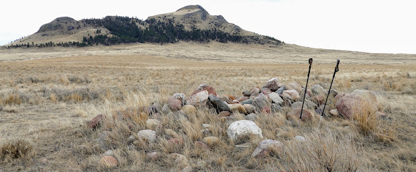
This is a type of rock called “tillite” (a type of diamictite). Tillites consist of poorly sorted* pieces ranging in size from pebbles to boulders, embedded in a matirix of mudstone or sandstone. Meltwater from an ancient glacier somewhere in Canada likely deposited the rock material in a low place near the melting glacier. Over time it lithified (became rock), then was plucked away by a more recent ice sheet, transported to north-central Montana as the ice flowed into this area, and then finally dropped onto the ground when the ice melted. It was found in a pile of erratics on the Fort Belknap Reservation in north-central Montana (see photo below).

*Poorly sorted means that the sediment contains a variety of different sizes of rock materials. River systems tend to sort rock materials according to size by typically depositing larger pieces (gravels) first in valleys, sand-sized pieces next near shorelines, and finally smaller silts and clays in deeper water environments. In contrast, glaciers simply drop whatever pieces they contain where the ice melts – no matter the size. This unsorted rock material is referred to as till.

Below: This pile of erratics is where the tillite shown above was found. Erratics are rocks that have been transported from another area by glaciers. Most of these are metamorphic rocks that came from the Hudson Bay area of Canada. A farmer placed them in this pile just west of Three Buttes (in backgroud), which is located in north-central Montana.

Thursday, November 11, 2021

Glacial Polish on the Fort Belknap Reservation in Montana

Above: Drone photo of me walking across an interesting outcrop - November 2021. Click on photo to enlarge.

The smooth surface of this outcrop of igneous rock in northcentral Montana is a great example of glacial polish. As the Laurentide Ice Sheet flowed across here thousands of years ago, the abrasive action of pebbles and sand stuck to the glacier's underside smoothed the surface and rounded the jagged edges. The outcrop is located near the southwest edge of Snake Butte, an impressive plutonic formation (laccolith) located on the Fort Belknap Reservation.

Subtle grooving in the rock prove that the ice moved across here was flowing toward the southeast. Other evidence, including distinct striations on another part of Snake Butte and a 50-mile long boulder train, confirms this. The southeastery flow was due to the influence of the nearby Bears Paw Mountains, which changed the glacier's flow from southward to southeastward.

CLICK HERE to learn much more about Snake Butte, including all about the Snake Butte Boulder Train.

Terms: abrasion, plutonic formation

Tuesday, October 26, 2021

Ancient Ash in the Missouri Breaks of Central Montana

Not a fossilized highway.
This photo was taken along an intermittent tributary of the Missouri River in the Missouri Breaks region of central Montana. The sediments exposed in the cut bank are part of the Bearpaw formation (aka Bearpaw shale). The silts and clays were deposited in the Western Interior Seaway, an inland sea that extended from the Arctic to the Gulf of Mexico during the mid to late Cretaceous period. The part of the sea that covered this part of Montana is sometimes called the Bearpaw Sea, named for the Bears Paw Mountains located 60 miles northwest of here.

Over millions of years the sea advanced and retreated across the region, changing the location of the shoreline and the depth of the water. In the meantime, occasional volcanic eruptions to the west spewed ash that winds carried over the sea. The thicker light-colored layer in the photo is ash from one of those eruptions. A few thinner deposits of ash are also exposed in the cut bank. Volcanic ash deposited in seawater changes over time; weathering converts it into a clay material called bentonite. Although it looks like ash from a distance, it feels like a sticky clay that has little resemblance to the ancient ash that settled here.

In addition to bentonite (altered ash) the Bearpaw formation contains a variety of marine fossils and some dinosaurs. Geologists estimate that sediments of the Bearpaw formation were deposited between 75 and 72 million years ago. In places the formation is 350 meters thick. Outcrops can be found in Montana as well as the Canadian provinces of Alberta and Saskatchewan. As the Western Interior Seaway retreated to the southwest, the Bearpaw shales were covered by deltaic and coastal plains sediments.

Terms: intermittent, deltaic sediments