Monday, January 24, 2022

#37 - Tillite Found Among Pile of Erratics in North-Central Montana

Life story . . .
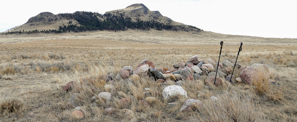
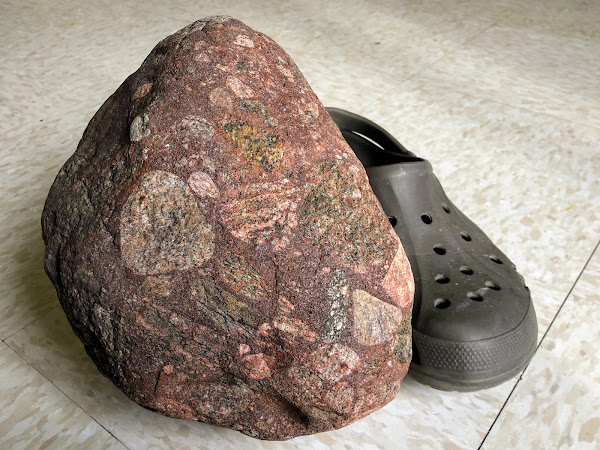
This is a type of rock called “tillite” (a type of diamictite). Tillites consist of poorly sorted pieces ranging in size from pebbles to boulders, embedded in a matirix of mudstone or sandstone. Meltwater from an ancient glacier somewhere in Canada possibly deposited the rock material in a low place near the melting glacier. Over time it lithified (became rock), then was plucked away by a continental glacier during a recent ice age, transported to north-central Montana as the ice flowed into this area, and then finally dropped onto the ground when the ice melted. It was found in a pile of erratics on the Fort Belknap Reservation in north-central Montana (see photo below).

Unsorted . . .
Poorly sorted means that the sediment contains a variety of different sizes of rock materials. River systems tend to sort rock materials according to size by typically depositing larger pieces (gravels) first in valleys, sand-sized pieces next near shorelines, and finally smaller silts and clays in deeper water environments. In contrast, glaciers simply drop whatever pieces they contain where the ice melts – no matter the size. This unsorted rock material is referred to as till.

Below: This pile of erratics is where the tillite shown above was found. Erratics are rocks that have been transported from another area by glaciers. Most of these are metamorphic rocks that came from the Hudson Bay area of Canada. A farmer placed them in this pile just west of Three Buttes (in backgroud), which is located on the Ft. Belknap Reservation in north-central Montana.

Term: lithification

Thursday, November 11, 2021

Glacial Polish on the Fort Belknap Reservation in Montana

Above: Drone photo of me walking across an interesting outcrop - November 2021. Click on photo to enlarge.

The smooth surface of this outcrop of igneous rock in northcentral Montana is a great example of glacial polish. As the Laurentide Ice Sheet flowed across here thousands of years ago, the abrasive action of pebbles and sand stuck to the glacier's underside smoothed the surface and rounded the jagged edges. The outcrop is located near the southwest edge of Snake Butte, an impressive plutonic formation (laccolith) located on the Fort Belknap Reservation.

Subtle grooving in the rock prove that the ice moved across here was flowing toward the southeast. Other evidence, including distinct striations on another part of Snake Butte and a 50-mile long boulder train, confirms this. The southeastery flow was due to the influence of the nearby Bears Paw Mountains, which changed the glacier's flow from southward to southeastward.

CLICK HERE to learn much more about Snake Butte, including all about the Snake Butte Boulder Train.

Terms: abrasion, plutonic formation

Tuesday, October 26, 2021

#107 - Ancient Ash in the Missouri Breaks of Central Montana

Geologist love cut banks! . . .
This photo was taken along an intermittent tributary of the Missouri River in the Missouri Breaks region of central Montana. The sediments exposed in the cut bank are part of the Bearpaw formation (aka Bearpaw shale). The silts and clays were deposited in the Western Interior Seaway, an inland sea that extended from the Arctic to the Gulf of Mexico during the mid to late Cretaceous period. The part of the sea that covered this part of Montana is sometimes called the Bearpaw Sea, named for the Bears Paw Mountains located 60 miles northwest of here.

Blowin' in the wind . . .
Over millions of years the sea advanced and retreated across the region, changing the location of the shoreline and the depth of the water. In the meantime, occasional volcanic eruptions to the west spewed ash that winds carried over the sea. The thicker light-colored layer in the photo is ash from one of those eruptions. A few thinner deposits of ash are also exposed in the cut bank. Volcanic ash deposited in seawater changes over time; weathering converts it into a clay material called bentonite. Although it looks like ash from a distance, it feels like a sticky clay that has little resemblance to the ancient ash that settled here.

Sea critters . . .
In addition to bentonite (altered ash) the Bearpaw formation contains a variety of marine fossils and some dinosaurs. Geologists estimate that sediments of the Bearpaw formation were deposited between 75 and 72 million years ago. In places the formation is 350 meters thick. Outcrops can be found in Montana as well as the Canadian provinces of Alberta and Saskatchewan. As the Western Interior Seaway retreated to the southwest, the Bearpaw shales were covered by deltaic and coastal plains sediments.

Terms: intermittent, deltaic sediments

Thursday, October 21, 2021

#76 - The Belt Meteor Crater - NOT!

Click on photo to enlarge.

FYI - I took this photo with a drone. That is me standing on the other side of the crater.

Wrong name.
The Belt Meteor Crater, which is located on private land in central Montana, was NOT made by a meteorite slamming into the prairie. It is actually a sinkhole, caused by the dissolution of limestone beneath the surface. The rim of the crater is made of sandstone, but a thick (up to 1700 feet) formation called the Madison limestone underlies the area. As water soaks down through soils above, it becomes slightly acidic. Then as this water works its way down through cracks, it dissolves away the limestone, forming caves. The sinkhole is 100 feet across and 40 feet deep, so a fairly large cave must have formed in the limestone not far beneath the surface here. Eventually the layers of sandstone above the cave collapsed onto the cavern floor to form the sinkhole.

Kill Site.
The Belt Meteor Crater once served as a buffalo jump, or "pishkun", for Native Americans as evidenced by bison bones and arrowheads on the floor of the hole. "Pishkun" is Blackfeet for "deep blood kettle." Scientists visited the sinkhole to collect bison bones that can be carbon-dated to determine when Indians used it. They also found an arrowhead(s) made of obsidian. Experts can determine where the obsidian came from by comparing its mineral composition with obsidian outcrops in the region. This can help provide insights about Native American trade routes.

Term: dissolution

Map of sinkholes in Florida - May home-owners in Florida actually buy sinkhole insurance!

More photos of the Belt Meteor Crater (Google Album)

Bigskywalker.com - lots of geology

Sunday, April 4, 2021

#131 - Huge Pile of Erratics in North-Central Montana

Drone photo - That's me in the lower left. Click on it to enlarge.
Come and go . . .
Earth has experienced several ice ages in the past, with the most recent one starting about 2.6 million years ago - the start of the Pleistocene Epoch. Over and over, continental glaciers from northern Canada grew toward Montana, advancing and then melting away once every 41,000 years. Mysteriously, about a million years ago the timing of the cycle changed from once every 41,000 years to approximately once every 100,000 years. The graph at the below shows the last four advances. They're labelled as "Glacials" on the graph, but are commonly referred to as "ice ages." Geologists believe that it was only during the last two glaciations that the continental glacier grew far enough to reach into present-day Montana, about as far south as the Missouri River. The most recent advance, referred to as the Wisconsin Ice Age, ended about 12,000 years ago (the end of the Pleistocene Epoch), and the one before it is called the Illinoian Ice Age.

Out of place . . .
The glaciers left all sorts of evidence as they advanced and then melted on the Hi-Line area. Many of these are hard to discern or unnoticeable to the untrained eye, but everyone who has travelled the area has seen the big random rocks on the prairie or big piles of rocks that dot the farmlands. Rocks like this were dubbed "erratics" by early geologists because they didn't match the type of rock that was natural to the area. "Erratic" comes from the Latin word errare, meaning to make a mistake or to wander. The rocks appeared out of place in their new surroundings. In fact those big erratics (and many smaller ones too) that travelers see on the Hi-Line hail from northern Canada, many from as far away as the Hudson Bay - and it is clear that they were transported here by coninental glaciers that grew into northern Montana during the Illinoian and Wisconsin Ice Ages.

Like a conveyor belt . . .
The continental glacier that eventually covered much of Canada and the northern part of Montana has been named the Laurentide Ice Sheet. Its primary growth center was Hudson Bay region. As the thickness of the ice grew and the glacier started to spread from from there it "plucked" pieces of rock from the bedrock - mostly metamorphic rocks. The rocks became embedded in the glacier and rode along until the matrix of ice melted centuries or even thousands of years later somewhere in Montana. That was the end of the line for the rocks.

Picking rock . . .
The glacial erratics are a nuisance to farmers who want to grow crops on the land. Farmers must first remove the erratics, either by manual labor or by using specialized machinery. The rocks are typically piled in an area that will have to be farmed around in the future. The photo atop this page is an extreme example of one of those piles - by far the biggest pile of erratics I've ever seen! It is located near the tiny town of Hogeland about 50 miles northeast of Havre (straight-line distance). Interesting these rocks were all brought here during the Illinoian Ice Age, not during the more recent Wisconsin Ice Age. Both Hogeland and neighboring Turner sit on the Boundary Plateau, known locally as the Big Flat, and apparently the Laurentide Ice Sheet was not thick enough to cover the plateau the last time it grew into the area. It did flow around it though.

Term: Pleistocene Epoch
Saturday, September 21, 2019

#16 - Mission Reservoir in Western Montana - A Moraine-Dammed Lake

This is Mission Reservoir in western Montana - about 50 miles north of Missoula. St. Ignatius (pop. 842) can be seen in the distance. The reservoir is actually a moraine-dammed lake formed by a valley glacier during the last ice age. It has been modified to serve as a reservoir.

The “lateral moraines” were deposited along the sides of a valley glacier (a.k.a. alpine glacier) during the last ice age. The moraines are the curved ridges along the sides of the reservoir. These forested ridges consist of rock material that the glacier removed from the mountains in the upper part of the drainage basin, high above the lake. Over the thousands of years since the moraine was formed, soil has formed on top and trees have taken root.

Right: Aerial photo of Mission Reservoir taken several years ago by Lawrence Dodge of Big Sky Magic Enterprises.

Below: This is similar to what the Mission Reservoir area probably looked like when the alpine glacier filled the drainage.

Rock material that has been transported and deposited by glaciers is called "till". As the glacier formed, rocks became stuck to its bottom and sides. Then as the ice flowed toward the valley floor, these rocks scoured away even more of the mountain’s surface. The glacial ice flowed to the position marked by the location of lake where it melted and dropped the rocks. For thousands of years, snowfall continued to replace the ice as it flowed away from the mountain tops. This "conveyor belt" took much of the mountain with it, forming the moraines. Much of the till deposited at the end of the glacier was washed away as the ice melted, so some of the original "end moraine” is missing. Since the end of the last ice age (10,000 years ago), soil has developed on the moraines and trees have taken root.

Geologists describe till as “unsorted” because it is made up of all sizes of rocks. This characteristic helps geologists distinguish materials deposited by glaciers from those deposited by running water, which tends to deposit different sizes of rocks in different areas.

Terms: lateral, till

Related Links . . .

1. CLICK HERE to access the blog post and photo tour of the hike I did to get the photo of Mission Reservoir.

2. CLICK HERE to watch a 3-minute drone video of the Mission Reservoir.

3. CLICK HERE to see a nice photo of Lake Wallowa in northeastern Oregona - another great example of a moraine-dammed lake.

Monday, July 29, 2019

Borah Peak Fault Scarp in Idaho formed during 1983 Quake

The thin tan line in this photo is the Lost River Fault Scarp, which runs for over 20 miles along the base of the Lost River Range in central Idaho. The scarp formed as result of a 6.9 M earthquake that occurred at 8:06 am on October 28, 1983. The quake was named the “Borah Peak Earthquake” because it happened near Borah Peak (12,662 ft.), the highest mountain in Idaho - the one on the left in this photograph. The photo was taken along the road to the Birch Springs Trailhead where hundreds of hikers come every year to begin their ascent of Borah (known locally as Mt. Borah).

The Lost River Range is a fault-block mountain range on the northeastern edge of the Basin and Range Province. Like Basin and Range Mountains in other states such as Utah and Nevada, these mountains formed one earthquake at a time over millions of years. During the 1983 quake the valley side of the fault dropped 9 feet and the block that includes the Lost River Range rose 6 inches, leaving the offset (scarp) shown in the photos.

The epicenter was located along the fault somewhere between the small towns of Mckay and Challis. Although it was the most energetic earthquake in the lower 48 since the 1959 Hebgen Lake Earthquake in southwestern Montana, there were only two deaths. Two children (ages 6 and 7) were killed in Challis when a brick wall collapsed on them as they walked to school. Shaking was felt in eight states and two Canadian provinces, lasting from 30-60 seconds.

Below: This photo, taken by Bruce Railsback of the University of Georgia, shows a person standing below the Lost River Fault Scarp (near bottom, center of photo). Bruce took the photo in in 1987, four years after the earthquake happened.

Links . . .

Newspaper coverage by the Idaho Statesman

Basin and Range Province (Wikipedia)

Climbing Mt. Borah (aka Borah Peak)

Fault-Block Mountains (Wikipedia)